Liffey Cycle Route
Feedback updated 14 Feb 2020
We asked
The Liffey Cycle Route is a Primary Route in the Greater Dublin Area Cycle Network Plan published by the National Transport Authority (NTA) in December 2013, and as such is a key objective of the NTA and Dublin City Council (DCC). It is one of a number of routes being developed by DCC as part of its overall 470km of safer cycling routes suitable for cyclists of all ages and abilities.
The scheme will deliver pedestrian improvements, a high quality cycle route that will meet the requirements of cyclists of varied experience and will provide an optimal balance of provision between the various road users along the route. The design will have particular regard to any engineering, architectural and environmental constraints along the route.
In 2017 DCC and the NTA agreed that the NTA would undertake a review of all design options considered to date and identify any new design options.
In March 2019 the NTA presented an Emerging Preferred Design to DCC.
This Emerging Preferred Design includes the following
• The existing road layout will be reconfigured to provide a one-way segregated cycle track on the north and south quays, located on the building side from the Phoenix Park to O Donovan Rossa Bridge where it then crosses to the river side of the road to Matt Talbot Memorial Bridge,
• Provision of boardwalks at various locations,
• Upgrade of junctions to provide pedestrian and cyclist improvements,
• Public realm improvements and
• Improvements to existing traffic signal operational infrastructure.
Dublin City Council carried out a non-statutory public consultation from 2nd May 2019 to 6th June 2019. We requested the views of the public and interested parties on all design aspects of the scheme.
You said
425 submissions were received as part of the non-statutory public consultation process conducted from 2nd May 2019 to 6th June 2019. All the received submissions are contained in the Appendix document which is available below.
We did
Dublin City Council has compiled a summary report. This summary report outlines the themes arising from submissions made by members of the public and specific bodies during the non-statutory public consultation process for the Liffey Cycle Route.
It should be noted that any views, thoughts and opinions presented in the summary report are those submitted during the non-statutory public consultation, and are not Dublin City Councils.
The Summary Document is available below.
Please see the attached Liffey Cycle Route NSPC Summary document in Microsoft Word Format
Please see the attached Appendix-Submissions Received document in PDF Format*
- Liffey Cycle Route NSPC Summary Document.docx, 31.2 MB (Office Word 2007 XML document)
- Appendix-Submissions received.pdf, 23.0 MB (PDF document)
Additional Submissions
- Blind Legal Alliance_R Sinnott Submission, 14.2 KB (Office Word 2007 XML document)
*Please note that a Microsoft Word version of the Appendix-Submissions received document will be available in early 2020
Scheme Update
Comments and observations received will be considered as the scheme design progresses.
Following extensive internal DCC consultation, key areas which require scoping prior to the engagement of an engineering service provider have been identified, DCC is currently progressing these scoping exercises. This information along with the comments received as part of the non-statutory public consultation will help in fully defining the scope of the scheme. This will form the basis for appointing a design team in Q2 2020.
Results updated 14 Feb 2020
Please see the attached Liffey Cycle Route NSPC Summary document in Microsoft Word Format
Please see the attached Appendix-Submissions Received document in PDF Format*
*Please note that a Microsoft Word version of the Appendix-Submissions received document will be available in early 2020
Files:
- Liffey Cycle Route NSPC Summary Document.docx, 31.2 MB (Office Word 2007 XML document)
- Appendix-Submissions received.pdf, 23.0 MB (PDF document)
- Blind Legal Alliance_R Sinnott Submission, 14.2 KB (Office Word 2007 XML document)
Overview
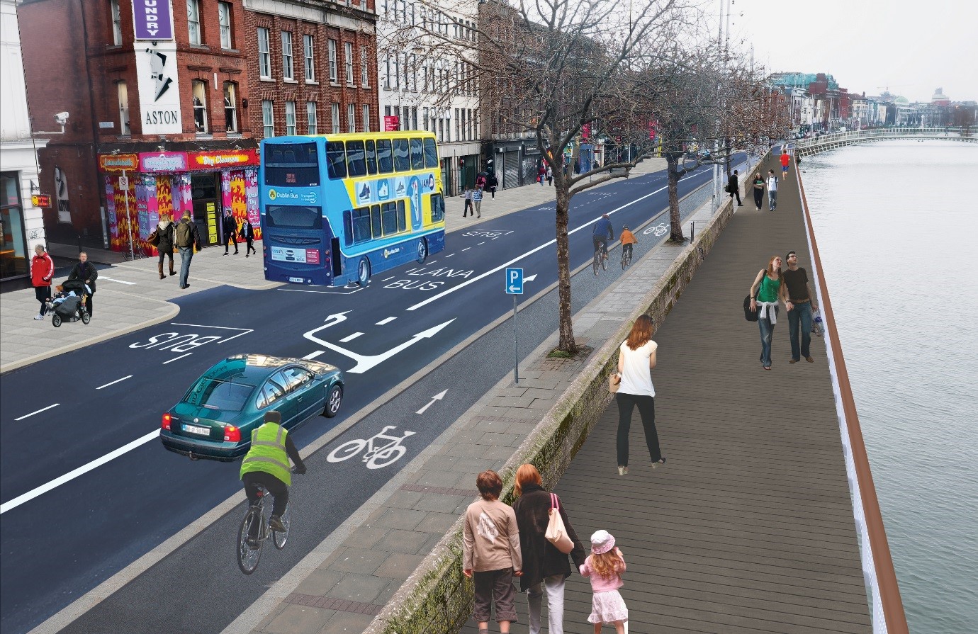
Fig 1.0 Proposed Arrangements for Aston Quay
Objectives
The Liffey Cycle Route is a key objective of the cycle network plan for the city and is one of a number of routes being developed by Dublin City Council as part of its overall 470km of safer cycling routes suitable for cyclists of all ages and abilities.
The objective of the scheme is to provide a high quality cycle route to meet the requirements of cyclists of varied experience having particular regard to any engineering, architectural and environmental constraints along the route, which provides for an optimal balance of provision between the various road users along the route, provide a broadly consistent cycle route in terms of alignment and feel; and cater for walking along the route.
Locations
Parkgate Street, Wolfe Tone Quay, Sarsfield Quay, Ellis Quay, Arran Quay, Inns Quay, Ormond Quay Lower, Ormond Quay Upper, Bachelors Walk, Eden Quay and Custom House Quay on the Northside and Victoria Quay, Usher’s Island, Usher’s Quay, Merchant’s Quay, Wood Quay, Essex Quay, Wellington Quay, Crampton Quay, Aston Quay, Burgh Quay and George’s Quay on the Southside.
The proposal includes;
- The existing road layout will be reconfigured to provide a one-way segregated cycle track on the north quays, located on the building side from the Phoenix Park to O Donovan Rossa Bridge where it then crosses to the river side of the road to Matt Talbot Memorial Bridge. On the south quays, the existing road layout will be reconfigured to provide a one-way segregated cycle track located on the river side from George’s Quay to O Donovan Rossa Bridge where it then crosses to the building side to Victoria Quay.
- Provision of boardwalks at various locations
- Upgrade of junctions to provide pedestrian and cyclist improvements
- Public realm improvements,
- Improvements to existing traffic signal operational infrastructure.
Scheme Benefits
- Safety improvements for walking, cycling and public transport
- Accommodating modal shift- Since 2012 cyclist numbers have doubled on the quays while bus numbers are up by 14%. Car numbers are down 50% on the north quays and down 33% on the south quays
- Car park assess will continue to be maintained.
- Increased capacity at bus stops.
Related Documents
Please find accessible versions of the Summary Document and the Route Options Assessment Report at the bottom of this webpage.
- Liffey Cycle Route Options Assessment Report.pdf 7.2 MB (PDF document)
- Liffey Cycle Route Summary Document.pdf 33.9 MB (PDF document)
- Liffey Cycle Route Drawings.pdf 24.3 MB (PDF document)
- Full Scheme Drawing.pdf 18.8 MB (PDF document)
Submissions
The proposed plans will be available for inspection from Thursday 02nd May to Thursday 06th June 2019 at;
- The public counter in the Civic Offices, Wood Quay, Dublin 8,
- Pearse Street Library, 144 Pearse Street, Dublin 2.
- Central Library, Ilac Centre, Henry St, Dublin 1
Please view these proposals and let us know your views. Representations in relation to these proposals may be made via the link below or in writing to:
- In writing to
- The Executive Manager,
Environment & Transportation Department,
Block 2 Floor 6,
Civic Offices,
Wood Quay,
Dublin 8.
Areas
- All Areas
Audiences
- Anyone from any background
Interests
- Traffic Planning and Movement
- Public Transport
- Pedestrian Movement
- Cycling
- Wayfinding
- Roads Design
- Roads Maintenance
- Road Licences
- Road Closures
- Taxi Ranks
- Planning
- Urban Design
- City Development Plan
- Forward Planning
- Public Realm
- Sports and Leisure
- Water and Drainage
- Climate Change
- All Interests
- All Services
- Gach Seirbhís
- Uile
Share
Share on Twitter Share on Facebook